Saturday, October 20, 2007

San Francisco


I recently visited San Francisco. This was my second visit, but this was my first chance to get a sense of the breadth and depth of what the city has to offer.

I stayed at the Hotel Adagio, which I highly recommend. It is more affordable than some of the name hotels, and conveniently located. The only caveat: it is right on the edge of the Tenderloin District. It isn't a problem at the hotel...just don't go right when you exit the hotel, because the quality of your experience will deteriorate rapidly.

The hotel is close to Union Square, which seems to be a hub of activity, and not far from the Metro sub station, which will take you just about anywhere you want to go for $1.50. That's the statue in Union Square. You can see the fog, which is a daily feature that does not lift until at least 10 a.m. Bring a sweater. It's always cold in the morning.

If you hang a left at Union Square, you'll soon be near Chinatown. I mostly walked the streets in Chinatown, soaking up atmosphere. I went into a couple of shops. Very touristy and over priced. Avoid the electronics stores, where they will flat out lie to you about what will work on your camera. One guy tried to sell me a lens for my camera that I knew wouldn't work. He started out at $500, and reduced it to $35 "just for me."

If you hang a right at Union Square, you'll go past a number of stores (e.g., The Gap) before arriving at the Metro station. You can go a long way on the train. In one direction, AT&T Park, where the San Francisco Giants play. That's worth a visit even without Barry Bonds.


In another direction, Golden Gate Park, a huge park on the order of 
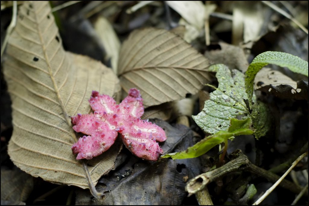
Central Park in New York, with public art, museums, botanical gardens and lots of people having fun. This pink head is one of the public art works on display, and the Conservatory of Flowers has an interesting collection of orchids, venus fly traps and pitcher plants.

For a completely different experience, take the Metro to the Mission District and walk around. Dip into alleys here and there to find some amazingly high quality graffitti. Here are examples of the graffitti and murals: Clarion Street alley, The Generator and Balmy Alley. Get a taco at one of the many taqueria's while you are in the Mission District.


Why the Metro, and not these beautiful streetcars? Because the streetcars are for tourists. They are slow, packed with people, and expensive ($5, each way). They also have a limited range of places to take you, and sometimes they decide not to stop at each scheduled stop. I rode one about half the distance advertised, because they decided not to make the other stops. We could catch another streetcar to keep going. It would be another $5. Makes a good picture, but avoid the ride.

Consider renting a bike. I used Blazing Saddles. I rented a bike for the day (about $35 for a high end mountain bike) and road across the Golden Gate Bridge. Here's a shot from the foot of the bridge. The only time it is strenuous is getting from this point up to the road where the bridge begins.
The bridge ride itself is safe and easy. There's a riding area that protects you from the cars. It is full of people walking, though, so you sometimes have to slow down a bit.

On the other side, you can swing right into the town of Sausalito, which is also full of people. It's restaurants cater to tourists, though you can ask the natives where to eat and they'll send you on the side streets for higher quality fare. If you swing left off the bridge, you can take your bike into the trails of the Marin Headlands. You'll find yourself in the hills above the ocean, with the top of the Golden Gate at eye level.

Not for the weak. Very, very strenuous climb on the road to the Headlands, and on the mountain biking trails. Some beautiful scenery makes it worth it. You can swing around in a loop to finish up in Sausalito. Then take the ferry back to the city. Blazing Saddles will sell you the ferry ticket when you rent the bike.

Monday, July 30, 2007

Sunset Crater in Arizona


Sunset Crater, a 900-year-old cinder cone in Arizona.

These shots were taken with a film camera, and the process that scans the negatives takes considerable time. Accordingly, I'm only posting two shots:

(1) Someone at Sunset Crater, chosen because it nicely shows the landscape. I'm not enough of a Photoshop expert to erase the person from the picture.


(2) Lichens growing in the volcanic rock. The rock is mostly basalt, with crystals of green olivine (not evident in this picture) and white or glassy feldspar.

Tuesday, February 21, 2006

Machu Picchu


There are no shortage of pictures of Machu Picchu. Once you see it, you just can't stop clicking the shutter. It is hard to imagine how this unbelievable site is in the middle of nowhere. I could not imagine what its discoverer must have thought when he stumbled upon it. It was probably a combination of breathtaking (as it is now) and scary. He might have imagined that a secret people were still living there.


If you've got any energy left, I suggest taking an extra hour and a half and climbing the mountain behind Machu Picchu, known as Wayna Picchu. It is 350 meters above the city. That's about 1,100 feet. It doesn't sound like much maybe, but it is basically straight up. At certain points the stairs are more like ladders. There are precipitous drops. You won't feel danger, but you'll find yourself on all fours every once and awhile. It is work. The reward? A spectacular backside, birdseye view of the city that a very small fraction of visitors get to see. The picture at left does not adequately convey the view (and the height).

When your tour of Machu Picchu is over, you head for the bus station and make your way down to Aguas Calientes, to sit with your sweaty friends and enjoy some food and drinks. If you didn't shower at Winay Wayna, this will be your first chance to wash your hands with something other than hand sanitizer, and to (yikes!) look in the mirror. Then it's over to the train station for the trek back to Cusco. The train has a sky light, and boy are the seats comfortable!

Inca Trail - Almost to Machu Picchu

Your third day is designed to get you to the large camp at Winay Wayna, which has creature comforts like showers and a bar. Most of you will want a beer. Badly!

On the way to camp, there are several other ruins. There's also an optional side trail where you can visit the Intipata ruins. You'll have to break off from the group to do this, but I recommend it. It adds an hour to your hike, but I was completely alone for that hour. Just me, the Andes Mountains and the Intipata ruins. There were even more orchids on this optional section than on the main Inca Trail.

After your relaxing final camp night, you'll wake up at the crack of dawn. Actually, before the crack of dawn -- 4:30 -- for the trek to Machu Picchu. You want to be at the Control point when it opens, to avoid people traffic. At several places along the way down, you'll have a chance to see the sun rising over the mountains.

You get some spectacular views of Machu Picchu as the sun peeks over the mountains and slowly begins to illuminate the Inca city, beginning with the temple. As huge as the city is, it is dwarved by the surrounding landscape.


Inca Trail - Flora


Along the Inca Trail is a variety of flora. Most of the trees on the edges of the ridges are relatively stunted, due to the winds. Take some time to look around. It is easy to get focused on the trail ahead and your own feet, to avoid stumbling. Don't forget to look up and around.

There are a tremendous number of orchids. If you are a photographer, be ready to shoot in low light. The orchids are very small (about dime-sized), so with the low light it can be difficult to get good shots. Remember, you probably won't be lugging around a tripod...at least not if you are carrying your own backpack. You might consider having a porter carry your pack (it's about $50 for 4 days), allowing you to carry a bit more photo gear.

Look for some of the less obvious scenery. There's some weird stuff in South America (at least to North American eyes). Here's a shot of a butterfly-shaped fungus. I badly wanted to take this with me, but that would not have been appropriate. It is probably illegal to take things from the trail, but even if it isn't, preserve it as best you can. The number of visitors to the trail these days is extremely high, so the chances of destructive behavior are high.

Inca Trail - Ruins

There are numerous ruins along the trail, and time is usually built in for exploring. If you have a good guide, you can learn quite a bit about the way the Incas lived.

The picture at left is Runkurakay, which is a only a short uphill hike on the morning of the third day, just before crossing the second pass.

Shortly after that, you'll come upon Sayaqmarka, and our guide spent considerable time walking us through the remnants of this ancient Inca town. You will again see examples of Inca stone work, and learn to tell whether a particular dwelling was intended for the lower or upper classes (hint: the upper classes received stone that was tighter fitting and with no mortar).

One suggestion: take some notes while you are walking. You will see so much, you will forget what everything is. Such is the case with the ruin on the left. I think it is Concha Marca, encountered shortly after Sayqmarka, but I cannot be sure.

Inca Trail - Dead Woman's Pass

The second day of the hike leads up to Dead Woman's Pass, and back down to Paqaymayu campsite. The trip up to Dead Woman's pass is approximately 1,100 metres (3,600 feet) and the trip down to the campsite is about 700 metres (2,200 feet). It spans approximately 12 kilometers, and is grueling. This is where you first sense the altitude (4,200 metres, or 13,750 feet), huffing and puffing your way up to Dead Woman's Pass.

Dead Woman's Pass is not named after someone who died there. There are a couple of peaks that natives describe as resembling a woman lying on her back. Hence the name. And it's cold and windy up there. Here's a picture of me looking goofy in whatever I had to keep my head warm. At least I didn't have my pack on.

It's lovely up there, but with another two hours of hiking before camp and 30 degree temps (I'm from Florida!), you can only linger so long.

Inca Trail - Getting Started


Needless to say the scenery on the Inca Trail in the Andes mountains is spectacular. I strongly recommend hiking the trail over 4 days, as opposed to arriving by bus at Macchu Picchu.

Your day will begin early, as you take a shuttle to kilometer 77, where the hike begins. After getting your permits from the warden at km 77, you'll cross a suspension bridge over the Urubamba River, and you are off on your way. At this point you are at about 2,600 metres (8,500 feet), and the scenery is already amazing.


You'll pass smaller ruins within a couple of hours of beginning your hike. Depending on which company you are hiking with (I recommend Peru Expeditions, which only books about 15 people in your party), you may stay at several campsites along the way. My first night was at Wayllabamba at about 3,100 metres (10,100 feet). Dusk was beautiful from the campsite, but boy was it cold overnight.


Outskirts of Cusco, Peru

That's Cristo Blanco on the left, from ground level, in the hills north of Cusco. I hiked up there from the city below...a little further than I anticipated.

My destination was the Qenqo ruins, about 500 metres (1/3 of a mile) east of Cristo Blanco. The walk to Qenqo from the Plaza de Armas is only 1,000 metres as the crow flies, but I am not a crow. It is at least three times as far on a winding road. You'll walk through some small villages (very destitute), so if that makes you uncomfortable, you should probably take a cab.

Qenqo is like visiting a fort, with crumbling walls and internal passageways. You might find yourself amongst a busload of children, as it seems to be a frequent field trip for 10 year olds. The focus at Qenqo is the Inca stone carving, which involved fitting gigantic blocks of stone together seamlessly, without any mortar or sealant.

The walk from Qenqo to the Sacsayhuaman ruins is pastoral (pictured above left). It is about 1,000 metres west of Qenqo, but it is worth the walk. You have to pay a small sum to enter the ruins, but the ruins are spectacular even from the outside.

Sacsayhuaman (pronounced a little bit like "sexy woman") is probably the most impressive set of ruins I saw in Peru. There are something like 21 bastions and the walls run for more than 350 metres (over 1,000 feet). The surrounding landscape is also gorgeous (at least it was in May), with the Inca stonework set against green grass and blue skies.

Religious Imagery in Cusco, Peru


Christian symbols are everywhere in and around Cusco.

There are a number of iglesias worth exploring, but the most magnificent is Cathedral -- beautiful inside and out. It has restricted hours for the public, so plan your visit. I also recommend the small church of San Blas, which is a small adobe building. It has a large wooden pulpit (apparently carved from a single block of wood) that you can spend about 45 minutes looking at.

The picture on the left is outside San Francisco (the church). San Francisco has its own square (the Plaza de San Francisco) which is less populated than the Plaza de Armas. It has a cupola with golden windows, which are magnificent as the sun goes down (though nearly impossible to photograph well).

The picture on the upper right is Cristo Blanco, visible from everywhere in Cusco, as it sits high on the northern hills. I don't know its exact height, but I would estimate about 10 meters (approx. 30 feet).

Cusco, Peru

These are images from Cusco, Peru, the closest jumping off point for the Inca Trail. Cusco is at high elevation, so it takes some acclimatization. The city is charming, despite its concession to the tourist trade.

The center of the city is the Plaza de Armas, from which each of these pictures was taken. The Plaza is lined with restaurants and shops, and is clearly designed as the focal point for tourists. Most of Cusco, however, is a nice blend of the familiar (to those of us from the Northern and Western hemispheres) and native. It helps to brush up on your Spanish. It is not so modernized that everyone speaks English (at the bank, for example).

Many of the hostels are quaint -- and inexpensive by American standards. You can pretty much walk anywhere from any of the hostels in Cusco. Get extra blankets, though. The rooms are not heated. I stayed at Hostel Amaru.

I highly recommend exploring the city at sunrise and sunset. It is beautiful, situated in a valley amongst the Andes mountains. Enjoying some tea in the Plaza before the other tourists awake is very pleasant. You also may avoid some of the native teenagers selling knick-knacks (although some of them are fun to talk to, and it's a good way to brush up on your Spanish).

There are innumerable cathedrals, which are beautiful inside and out. Take the time to explore a palace or two as well. Most of them are now hotels, but with a little imagination you can envision how they once were.

While you are there, try some native dishes. My favorite lunch spot was Pacha Papa in the San Blas area. It is a patio restaurant with an outdoor clay (or stone?) oven. For artsy dinners, try Macondo or Fallen Angel. Both are gorgeous, and have incredible food. I also enjoyed my after-dinner coffee and conversation at The Muse and a quiet casual dinner at the Blueberry Lounge.